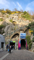

There was no itinerary. I just looked at Google Maps and discovered that IBIS Budget was right next to one of the bridges leading straight to the hiking trail going up to the castle. The castle is called Schlossberg, which literally translates to Castle Mountain. Very creative name. Lots of imagination was used in naming this place. *rolleyes*. The hike is not that hard but I suggest you do it from the entryway where the lift is. There’s also a hiking trail there but it's scenic. The hiking trail I ended up in was boring AF and all gravel and pavement.


You will see on the map that the area is one big green park overlooking the Mur river, which makes for a relaxing hike as long as it’s not raining. I have to thank the gods for giving us a sunny day today. It became colder as the sun went down but hey, we’re not complaining. The sunset pics on my phone are amazing, not to mention it’s nice to be walking around dry for a change. And now, back to Schlossberg.


Wikipedia says that the castle’s history goes back to the 10th century, which puts it on equal footing with the castles we saw in Salzburg. The castle was heavily bombed when Napoleon invaded, even though the clock tower and the bell tower survived because the people of the city ransomed them, or at least that’s what is written on Wiki. Nowadays, the hill and the castle are properties of the city of Graz, administered by Holding Graz.

Aside from being an intensive park with an abundance of benches you can claim as your own at the parks themselves and the various terraces overlooking the old town center, there are also some ubiquitous attractions such as a Chinese pavilion, a restaurant and skybar as well as a free air concert venue called Kasematten. Since I did not take the lift, I wasn’t able to see one of the tunnels used to protect the citizens from aerial bombings back in the day. I did descend using the scenic stairs, though.

Heading down from the clock tower leads you straight to the town center. Dubbed as the Hauptplatz or main square in German, this plaza you are staring at is a UNESCO World Heritage site, my freund. They have the cobbled alleys, those colorful houses in a row, and of course the Rathaus. I guess what I did not like about what they did to the area was the abundance of white tents, which I understood to be stalls for various food and wares to sell. It looked like an evacuation center, which explains why most of my photos were taken from a low angle pointing up.

The vicinity of the square contains several churches and monuments but what I liked the most were the colorful flowers that complement them on the ground. It looks like Spring has indeed arrived despite the cold spells from time to time. Once you are done sightseeing and taking pictures in this area, which I bet you will be plenty, it’s time to cross over to the other side of the river. I suggest you pass by Murinsel, a man-made island they constructed right at the middle of the Mur river.

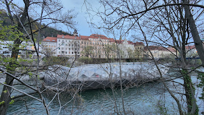
I did not pass through it because I was already tired from almost two hours of walking so I just zoomed in via my phone camera to see what’s inside and what I saw looked like stadium benches of sorts. Strange. Anyway, it looks like a floating steel turd in the middle of the river, a modern deviation from the classical buildings in its background. Another modern attraction on this side of the island which is hard to ignore is Kunsthaus Graz, which looks like a cross between a spaceship and a steel heart twinkling with yellow lights at night. Mariahilferplatz is a block or two away, with the church dominating it.


0 creature(s) gave a damn:
Post a Comment